What the Kp index means for drone pilots
It's easy to see a high Kp in a drone app and wonder whether to cancel your flight. Here's what Kp actually measures, what NOAA says geomagnetic storms can do, and how to use it before you fly.
What Kp measures
The K-index measures disturbances in Earth's magnetic field. NOAA's Space Weather Prediction Center publishes the planetary version, Kp, which averages readings from magnetic observatories around the world. Each value covers three hours, on a scale from 0 to 9, and anything 5 or above counts as a geomagnetic storm.
Storms happen when bursts of solar wind, often from eruptions on the Sun, disturb Earth's magnetic field. NOAA's Kp page shows the latest estimate.
The scale, level by level
NOAA names five storm levels, G1 to G5, and describes what each can do. For drone pilots, the line to watch is satellite navigation.
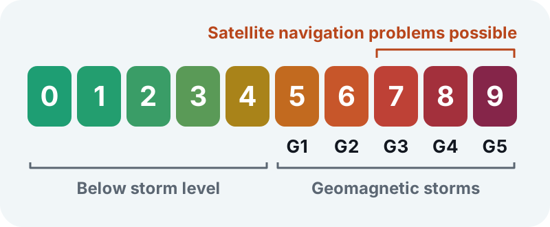
- Below Kp 5: below storm level.
- G1, Kp 5 (minor): NOAA lists no effect on satellite navigation. Auroras are common at high latitudes.
- G2, Kp 6 (moderate): still nothing listed for satellite navigation, though high-frequency radio can fade at higher latitudes.
- G3, Kp 7 (strong): intermittent satellite navigation problems may occur.
- G4, Kp 8 (severe): satellite navigation can be degraded for hours.
- G5, Kp 9 (extreme): satellite navigation may be degraded for days.
Strong storms are also much rarer. In an average 11-year solar cycle, NOAA counts about 900 days with minor storms, about 130 with strong ones, and only 4 with extreme ones. The full details are on NOAA's space weather scales.
What it means for your drone
Your drone uses satellite positioning, from GPS and often other systems like Galileo and GLONASS, to hold its place in the air, fly automated routes, and find its way home. According to NOAA's scale, navigation problems become possible at G3 and get worse from there. Below that, a high Kp alone isn't a reason to cancel.
Day to day, your surroundings often matter more. Tall buildings, cliffs, and trees can block or bounce satellite signals, and nearby metal, like cars, railings, or rebar in concrete, can throw off your drone's compass.
On a high-Kp day
- Wait for a solid fix. Check your drone app's satellite count or GPS status before takeoff.
- Test position hold. Hover low for a moment and make sure the drone stays put.
- Stay closer. Keep the drone nearer than usual, and during strong storms, save GPS-dependent jobs like waypoint missions and mapping for another day.
- Be ready to fly it yourself. If your drone loses its position lock, it will drift with the wind, and you'll need to fly it back by hand.
How Flyby uses Kp
Flyby reads NOAA's near-real-time Kp estimate and folds it into your Fly Score:
- Below Kp 5, it costs nothing.
- From Kp 5, the score loses points, from 2 in a minor storm to 25 in an extreme one.
- From Kp 7, strong storms also cap the score: at most 75 at Kp 7, 60 at Kp 8, and 50 at Kp 9.
Kp readings older than 90 minutes are left out of the score, and the confidence label tells you when the Kp data isn't current. What shapes your Fly Score covers the rest of the math.
The upside: auroras
Strong storms push auroras far from the poles. NOAA notes that during G3 storms, auroras have been seen as far south as Illinois and Oregon.
If you head out to film one, remember that it's night flying. In the US, Part 107 pilots need anti-collision lighting visible for at least 3 statute miles at night and during civil twilight, plus updated training to fly at night. Recreational flyers who fly at night must follow a community-based organization's safety guidelines, which spell out the lighting you need. Check 14 CFR 107.29 and the FAA's recreational flyer guidance before you go.